Drone Surveys for Construction Sites in Essex and Tendring
High resolution drone mapping, earthwork volumes and site monitoring for builders and developers.
We provide drone surveys for construction sites across Essex and Tendring. Our drone mapping delivers high-resolution orthomosaic site maps, stockpile volume calculations and progress reports that help builders and developers make faster, more confident decisions.


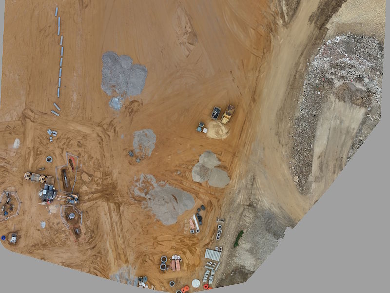
Orthomosaic map with length, area and volume measurements
📐 Accurate Site Data at a Glance
Tendrone’s high-resolution orthomosaic maps turn complex construction sites into easy-to-read, measurable visuals. In this example, you can clearly see how resource piles are mapped and measured with precision, saving you time, reducing material waste, and supporting smarter planning.
Using drone-captured data, we provide:
-
Accurate area and volume measurements of aggregates and stockpiles
-
Georeferenced site overviews for improved coordination
-
Data you can share with teams, clients, and contractors
Ideal for stockpile volume surveys, cut and fill checks and quick site measurements between full topographical surveys.
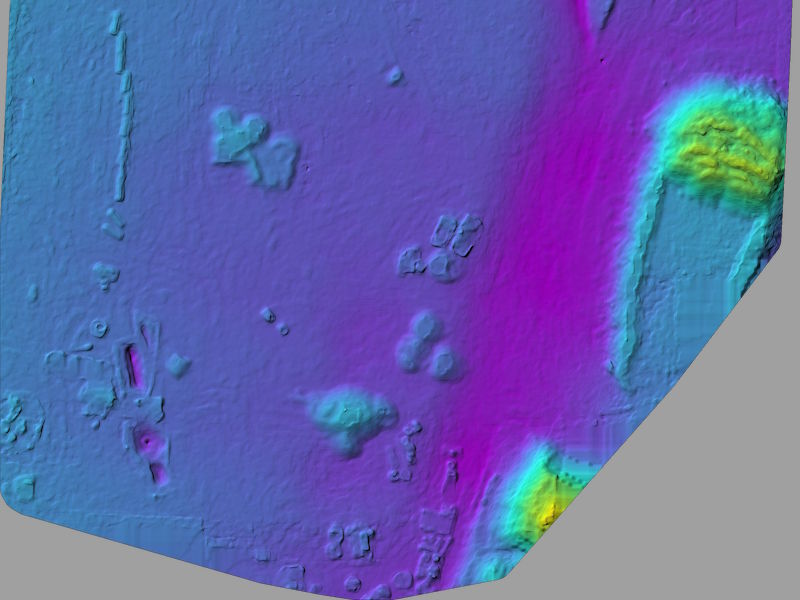
🗺️ Understand ground conditions at a glance
Our drone surveys capture both the high-resolution aerial image and a detailed surface model. Use the slider to reveal the ground shape, slopes and height changes that are hidden in normal photos. It is a quick way to understand levels, track earthworks and make better decisions for the site.
What this comparison helps you see:
-
Height changes and level differences across the site
-
Areas that may need cut and fill
-
Material movement and stockpile growth
-
Potential drainage issues before they become a problem
-
Access routes and working areas that need adjustment
Why builders and site managers use this:
-
Saves time on surveys
-
Reduces site visits
-
Gives a visual record for reporting and planning
-
Helps avoid costly mistakes during groundwork
🚁 Real-World Problems Solved by Our Drone Services

📍 Limited Visibility on Construction Sites
Solution: Aerial Mapping That Reveals the Full Site Picture
From Harlow to Harwich and everywhere in between, local sites are constantly changing. Ground-level views don’t give you the whole picture.
With Tendrone, you get high-resolution aerial mapping that helps you:
- See your entire site from above. Layout, drainage, access points, and more
- Identify potential delays before they escalate
- Support planning and reviews with map overlays and visuals
Our ortho maps are perfect for project visibility. Although our standard maps are not survey-grade, they are high definition and ideal for fast, actionable insight.

📍 Poor Communication Between Teams
Solution: Shareable Visuals to Keep Everyone on the Same Page
Whether your contractors are in Clacton or your client is based in London, miscommunication slows down progress.
Tendrone helps you stay aligned by delivering:
- Ortho maps that can be shared digitally or projected in meetings
- Aerial photos and videos to update remote stakeholders
- CAD overlay capability to confirm builds are in the right place
No more guesswork. Just clear, visual updates that keep everyone informed.

📍 No Clear Record of Construction Progress
Solution: Regular Visual Updates That Track Every Stage
Tracking progress can be difficult, and without documentation, it’s hard to resolve disputes or justify delays.
Tendrone provides regular drone captures to:
- Document each stage of your project visually
- Create a timeline of development from start to finish
- Support EOT claims or defend against potential delays
- Reduce the time and cost of legal disputes with visual evidence
We work flexibly around your site schedule with fast turnaround.

📍 Slower Decision-Making on Active Sites
Solution: Real-Time Aerial Insight for Faster Action
When site issues arise, decisions can’t wait.
With Tendrone’s weekly or monthly drone visits, you get:
- Real-time aerial perspectives to identify risks or hold-ups
- Updated maps and imagery for strategic planning
- The ability to act faster and reduce project downtime
Stay informed. Act quickly. Avoid costly setbacks.

📍 Low-Quality Visuals for Clients or Investors
Solution: High-Impact Drone Photography & Video for Essex Projects
Whether you’re showcasing a housing development in Colchester or preparing for your next investment round, quality visuals matter.
Tendrone captures stunning drone content you can use for:
- Property marketing and brochures
- Client and investor updates
- Progress reports and promotional videos
- Social media and website content
Delivered fully edited and ready to use.

📍 Costly Earthwork Miscalculations
Solution: Precision Earthwork Analysis with Drone Technology
Accurate terrain data is essential when you’re planning or managing large-scale groundwork. Traditional surveying can miss the mark — leading to costly errors.
Tendrone’s aerial surveys provide high-quality data you can rely on for:
-
High-resolution topographic maps and 3D terrain models
-
Cut and fill volume calculations for excavation planning
-
Smoother coordination between teams and contractors
-
Reduced risk of rework, delays, and budget overruns
All delivered quickly, digitally, and ready to support smarter decisions.
Why Choose Tendrone?
Benefits of Drone Services
Enhanced Efficiency
Our drones provide rapid data collection, reducing the time needed for site surveys and allowing for quicker project turnaround.
Improved Safety
By using drones, we minimize the need for workers to access hazardous and hard to reach areas, significantly lowering the risk of accidents.
Cost Savings
Drone technology reduces the need for expensive equipment and labor, helping you stay within budget.
Precision Mapping
High-resolution imagery and detailed 3D models ensure accurate site assessments and planning.
Real-Time Monitoring
Our drones provide live updates, allowing for immediate adjustments and better project management.
Comprehensive Reporting
Receive detailed reports that enhance decision-making and project oversight.
❓Frequently Asked Questions
How accurate are your drone surveys for construction sites?
For most construction monitoring, earthworks checks and stockpile volume surveys, our drone data is accurate enough to support planning, measurements and volume estimates. For legal boundary work or setting out, you should still use a chartered land surveyor and we can work alongside them.
Can drone surveys replace a traditional topographical survey?
For many builders and developers, drone surveys give all the visuals, levels and volumes they need between full topo surveys. We are not a replacement for a full measured survey where one is required, but we are a fast and cost effective way to keep site information up to date.
What areas do you cover?
We are based in Tendring and mainly work across Essex and Suffolk, but we can travel further for the right projects. Get in touch with your site location and we will confirm availability.
How much does a construction drone survey cost?
Most construction drone surveys in Essex start from around £400 for small, straightforward sites. Typical projects that include orthomosaic maps, stockpile volumes or progress reporting usually fall between £800 and £1,200. Larger sites or surveys needing more detailed outputs such as cut and fill calculations or regular monitoring are generally priced from £1,200 to £2,000, depending on the size and complexity of the site. Travel costs may apply based on location.
Unlock Precision with Our Drone Expertise
Discover how our cutting-edge drone technology can transform your construction projects. Contact us today to schedule a consultation and explore the benefits of accurate aerial insights tailored to your needs. Let’s build smarter together.